Japan · Nagano

Kurumayama Kogen SKYPARK

車山高原SKYPARKスキー場
22 / 100 Powder Score
No Snow Weather Partly cloudy
Official site

Not open yet for 2026/27. We have not yet found an official opening date. The snowfall below is a model figure and does not mean the slopes are skiable.

Base depth
0cm
Snow 48h
1cm
Next 72h
0cm

A weather-model figure, worked out the same way for every ski area, and lower than what actually falls. Use it to compare ski areas, not against the resort’s own totals. How we measure →

Snow 24h
1 cm
Next 24h
0 cm
Temperature
−2°C
Max wind
13 km/h
Elevation
1,569–1,911 m
Across
1.8 km

Updated: 10 Nov 2026, 12:15

7-day outlook

Date Weather Snow (cm) Low / high (°C) Wind (km/h)
Tue 10 Nov Snow 1 −4 to 0 13
Wed 11 Nov Partly cloudy 0 −4 to 4 10
Thu 12 Nov Clear 0 −1 to 9 8
Fri 13 Nov Cloudy 0 1 to 10 13
Sat 14 Nov Cloudy 0 3 to 12 14
Sun 15 Nov Cloudy 0 5 to 13 13
Mon 16 Nov Fog 0 1 to 9 8

Score breakdown

Fresh (48h) 3/40
Forecast (24h) 0/25
Snow quality 11/20
Wind 8/10
Base 0/5

The five add up to the 100-point Powder Score: more fresh snow, more on the way and colder air all push it up. How we measure

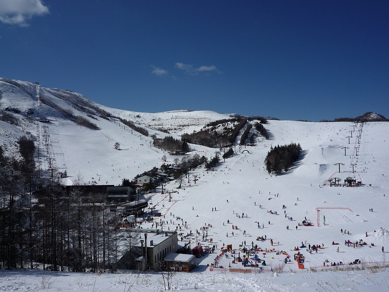
Snow and slopes at Kurumayama Kogen SKYPARK
Photo: Ski Mania / Public domain / Wikimedia Commons

Lifts climb all the way to the summit of Kurumayama, the main peak of Kirigamine. An observation terrace opened on the summit's south slope in December 2020, looking out to Yatsugatake, Mount Fuji and the Southern Alps. Snowshoers can explore the snowfields behind the ski area, but the Kurumayama and Yashima marshes are national natural monuments and stay off-limits even under snow. Sources: city.chino.lg.jp, winter.kurumayama-skypark.com, kurumayama.com (sources read 12 Oct 2026; an AI draft the site operator has not yet checked)

Runs and lifts

Counted from the runs and lifts drawn on OpenStreetMap, within the boundary of the ski area. These are not the resort’s own published figures.

Marked runs
12
Run length
7.3km
Lifts
8
Vertical
342m
Top 1,911 m · base 1,569 m

Run map

EasyIntermediateAdvanced Lift
North is up. Runs are coloured by difficulty; black lines are lifts.
Run map

Drag to move around, and use + and − to zoom. On a phone, swipe to move and pinch to zoom in further.

Slope shape, difficulty and lift types

The shape of the mountain

Longest run on the map1.8 km
Steepest pitch30°measured over at least 30 m
Average gradient of the runs11.7°

Which way the slopes face

North 12%
East 69%
South 18%
West 2%

81% of the vertical on the runs descends to the north or east. Those slopes get the least sun, so the snow lasts longer.

By difficulty

Easy 4 · 3.7 km
Intermediate 5 · 2.3 km
Advanced 3 · 1.2 km

Lift types

  • Chairlift8

See past trail maps on Skimap.org ↗

Source: OpenSkiMap (© OpenStreetMap contributors, ODbL 1.0). How finely ski areas are drawn varies by region, so treat the counts as indicative. Vertical is the difference between the highest and lowest points of the mapped runs and lifts.

Live cameras

This ski area does not put a camera on its own slopes. The nearest live view is the road below.

Footage remains the copyright of each operator. JAPANSNOWLINE neither stores nor redistributes it.

How much snow it gets

Modelled from weather data the same way at all 3,069 ski areas we cover. These are not the resort’s own published figures.

Seasonal snowfall
133cm
per season
Worst of 12 winters
96cm
The middle winter of the 12: 134 cm. The best: 182 cm.
World rank
1909
of 3,069 worldwide
Rank in country
344
of 397 in Japan
Elevation rank
20
Highest to lowest, of 397 in Japan. The centre point sits at 1,688 m, 922 m above the national median.
Quality rank
248
of 397 in Japan
Temp when snowing
−5.7°C
Japanese median: −3.6°C
Rain days
11%
Japanese median: 16%
Days over 5 cm
6%
Japanese median: 15%
Wind when snowing
18km/h
Average daily peak, 10 m above ground across a model grid cell; not the wind on ridges or lift tops
Dryness 55
Frequency 17
Freedom from rain 71
Calm when snowing (model grid) 96

The tick marks the median across every Japanese ski area we measure. All four bars run the same way — longer is better.

The quality score leaves out how much snow falls (it uses temperature, frequency, rain and wind).

Compared with what is nearby

Within 50 km in a straight line. Ski areas in the same weather-model cell (about 30 km across) get the same figure.

Ski areaDistanceSeasonal snowfallWorld rank
Shirakabako Royal Hill3.1 km133 cmsame grid cell1909
Blanche Takayama3.7 km131 cm1942
Family Gelände Kirigamine Ski Area4.0 km133 cmsame grid cell1909
Shirakaba 2 in 14.9 km133 cmsame grid cell1909
Tateshina Tokyu Ski Area6.0 km136 cm1860

Compare side by side with Shirakabako Royal Hill and Blanche Takayama →

When it falls, and how winters differ

Month by month

The most snow falls in March. March brings as much as January, or more. In amount, March brings 46 cm, about the same as the median of 46 cm.

23cm
Dec
33cm
Jan
32cm
Feb
46cm
Mar
Average snowfall by month, last 12 winters

Winter by winter

Across the 12 winters measured, the average is 133 cm, and 5 of them fell short of it. The leanest was 2015/16 with 96 cm; the biggest was 2014/15 with 182 cm (1.9 times as much).

182
96
137
124
128
134
123
149
137
156
133
98
14/1515/1616/1717/1818/1919/2020/2121/2222/2323/2424/2525/26

Snowfall each winter (December–March total). The dashed line is the average; the numbers mark the leanest and the biggest winter.

How these figures are made

Hot springs nearby, as analysed

1 hot spring sources with published analyses lie within 5 km of this ski area, nearest first (the hottest is 61.6 °C).

Show the sources
SourceDistanceTemperaturepHTypeAnalysed
白樺湖ビーナス温泉2.9 km61.6℃ hot6.6 neutralchloride, sulphate1992

These are analyses of hot spring sources, not a list of baths you can visit. They date from 1910 to 2005, many from decades ago, so today’s temperature and chemistry may differ. Names are as recorded in Japanese. Temperature and pH bands follow Japan’s standard for analysing hot springs.

Source: processed from the hot spring analysis data in the Geothermal Information Database (GRES-DB), Geological Survey of Japan, AIST

Worth seeing nearby

Within 20 km in a straight line, nearest first. Some lie over a pass that is closed in winter.

Show the list
PlaceTypeDistance
Kurumayama車山Mountain0.9 km
Mount Kirigamine霧ヶ峰Mountain3.5 km
Lake Megami女神湖Nature6.6 km
Mount Tateshina蓼科山Mountain8 km
Lake Suwa諏訪湖Nature12.5 km
Suwa taisha諏訪大社Shrine14.1 km

Chosen from the places most read about on Wikipedia, favouring those with an English article. Based on the Japanese Wikipedia lists of sights in each prefecture, as compiled in travel-log-data (CC BY-SA 4.0). English names from Wikidata (CC0). The content of this section is available under CC BY-SA 4.0.

Map

The weather map, and where it sits among nearby ski areas.

Official piste map ↗

Going with children

Kids’ area
Yes (details in Japanese on the official site)
Childcare
Yes (details in Japanese on the official site)
Parking
Yes (details in Japanese on the official site)
Rental
Yes (details in Japanese on the official site)

Checked on the official site (12 Oct 2026) · Source. Compare with other ski areas →

Places to stay nearbyPR

Contains advertising. Property names and Rakuten Travel’s booking pages are in Japanese.

72 properties on Rakuten Travel lie within about 3 km of this ski area. The table shows the nearest 12 with a listed price.

Property (links to Rakuten Travel)Lowest listed (per person, tax incl.)RatingDistanceGetting there
GUESTHOUSE HO ALOHA 4SEASONS ¥5,800—0.7 km茅野駅/下諏訪駅:車で約35分、諏訪IC/佐久IC:車で約40分
車山高原 プチホテル ネーベルハウゼ ¥10,5003.00/5 24 reviews0.7 kmJR中央線茅野駅よりバスで50分。最寄バス停車山高原で下車、バス停より徒歩1分。
ローザンヌ ¥17,3004.33/5 45 reviews0.8 kmJR中央線・茅野駅より車山高原行きバス60分/中央道・諏訪IC~40分、上信越道・佐久IC60分
ホテル・アンナプルナ ¥17,380—0.9 km中央線 茅野駅よりお車にて50分
信州車山高原の宿泊できるレストラン オーベルジュ ラ・メイジュ ¥19,2504.63/5 216 reviews0.9 kmお車の場合・中央自動車道諏訪ICより約40分、諏訪南ICより約40分 バスの場合・JR茅野駅→車山高原約60分
花の宿B&B思いのまま ¥8,0004.33/5 42 reviews1.0 km茅野駅より車山高原行きバス
車山リゾートホテル ギャラクシー ¥10,8004.67/5 95 reviews1.0 kmJR茅野駅よりバスにて30分
プチペンション パオパオ ¥6,0004.83/5 40 reviews1.1 km茅野駅よりバスにて約1時間、車山高原スキー場から車で4分
車山高原ゲストハウス うらら ¥4,6004.33/5 44 reviews1.2 kmJR茅野駅よりお車にて約30分
Eco─Stay TOSS ¥6,2504.60/5 33 reviews1.3 kmお車 車山高原バス停より送迎あり(無料)
プチホテル花南 ¥6,3003.90/5 95 reviews1.3 km中央道 諏訪ICから車で約47分
リゾートイン ミスティ ¥7,0004.64/5 84 reviews1.3 kmJR茅野駅よりバスで50分
Pick dates and guests to check rooms on Rakuten Travel

Prices are the lowest Rakuten Travel lists; a property name, or “Pick dates and guests” above, shows prices and rooms for your dates.

Contains advertising. Property names and Rakuten Travel’s booking pages are in Japanese. · Property data by Rakuten Travel (Supported by Rakuten Developers)

Places to stay on the map

3 places within 12 km of the slopes, as mapped on OpenStreetMap, many of them small inns and pensions. Many are not on booking sites — open the name for the website or the map.

Nearest: 0.8 km

Show the nearest places

Nearest first

Accommodation data: OpenStreetMap

Other booking sites: Booking.com ↗ · Agoda ↗ · Rakuten Travelad ↗

“ad” marks links that pay us a commission if you book. Links without it are not affiliated.

Guides covering Nagano

← Ski areas in Nagano Compare with other ski areas →