【関温泉】豪雪メンツルパウダーで優勝!(2025.12.27 スノボー)
By: HAYATE OutdoorLife · 28 Dec
Not open yet for 2026/27. We have not yet found an official opening date. The snowfall below is a model figure and does not mean the slopes are skiable.
A weather-model figure, worked out the same way for every ski area, and lower than what actually falls. Use it to compare ski areas, not against the resort’s own totals. How we measure →
This season so far (1 Nov to 9 Nov): 22 cm, 128% of the average for the same dates. The average is over twelve winters on the same weather model. Across Japan →
Updated: 10 Nov 2026, 12:15
| Date | Weather | Snow (cm) | Low / high (°C) | Wind (km/h) |
|---|---|---|---|---|
| Tue 10 Nov | Drizzle | 0 | 0 to 3 | 9 |
| Wed 11 Nov | Cloudy | 0 | 0 to 5 | 7 |
| Thu 12 Nov | Partly cloudy | 0 | 3 to 11 | 8 |
| Fri 13 Nov | Cloudy | 0 | 4 to 13 | 7 |
| Sat 14 Nov | Cloudy | 0 | 6 to 13 | 7 |
| Sun 15 Nov | Rain | 0 | 8 to 14 | 6 |
| Mon 16 Nov | Showers | 0 | 1 to 9 | 10 |
The five add up to the 100-point Powder Score: more fresh snow, more on the way and colder air all push it up. How we measure
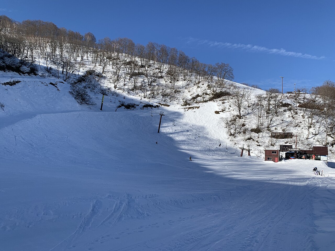
Seki Onsen, designated a National Health Resort Hot Spring together with Tsubame Onsen in 1972, has its ski slopes inside the village itself, so the inns and the runs share the same ground. Halfway up the hill, the Taube restaurant stands where the Skyline and Lerch courses meet. Sources: sekionsen.jp, env.go.jp, niigata-kankou.or.jp (sources read 12 Oct 2026; an AI draft the site operator has not yet checked)
Counted from the runs and lifts drawn on OpenStreetMap, within the boundary of the ski area. These are not the resort’s own published figures.
78% of the vertical on the runs descends to the north or east; plenty of the terrain faces the sun as well, so the lean is modest.
See past trail maps on Skimap.org ↗
Source: OpenSkiMap (© OpenStreetMap contributors, ODbL 1.0). How finely ski areas are drawn varies by region, so treat the counts as indicative. Vertical is the difference between the highest and lowest points of the mapped runs and lifts.
This ski area does not put a camera on its own slopes. The nearest live view is the road below.
Footage remains the copyright of each operator. JAPANSNOWLINE neither stores nor redistributes it.
Myoko and Joetsu webcams & snow report — all 11 ski areas →
Videos remain the copyright of whoever filmed them. JAPANSNOWLINE stores no video and plays everything through the standard YouTube player.
Modelled from weather data the same way at all 3,069 ski areas we cover. These are not the resort’s own published figures.
The tick marks the median across every Japanese ski area we measure. All four bars run the same way — longer is better.
The quality score leaves out how much snow falls (it uses temperature, frequency, rain and wind).
Within 50 km in a straight line. Ski areas in the same weather-model cell (about 30 km across) get the same figure.
| Ski area | Distance | Seasonal snowfall | World rank |
|---|---|---|---|
| Kyukamura Myoko | 1.2 km | 445 cm | 117 |
| Akakura Onsen Ski Area | 1.5 km | 445 cm | 117 |
| Akakura Kanko Ski Resort | 1.7 km | 445 cm | 117 |
| Ikenotaira Onsen Alpen Blick Ski Resort | 3.6 km | 432 cm | 129 |
| Myoko Suginohara | 4.4 km | 357 cm | 268 |
Compare side by side with Kyukamura Myoko and Akakura Onsen Ski Area →
The most snow falls in January. March brings 44% of January’s snowfall. That is a steeper fall than the median for ski areas in Japan (52%): the snow here is concentrated early in the season. For skiing, though, the amount matters more than the share: March brings 103 cm, more than the median of 46 cm.
Across the 12 winters measured, the average is 689 cm, and 5 of them fell short of it. The leanest was 2015/16 with 273 cm; the biggest was 2024/25 with 867 cm (3.2 times as much).
Snowfall each winter (December–March total). The dashed line is the average; the numbers mark the leanest and the biggest winter.
Total snowfall from December to March recorded at the 信濃町 weather station — 11.4 km from this ski area, 314 m below its mid-slope.
| Three-season average | 545 cm |
| 2023/24 | 550 cm |
| 2024/25 | 683 cm |
| 2025/26 | 403 cm |
The figure calculated on this page is 748 cm.
A weather station is not a ski slope. We picked one at a similar elevation, but it stands in a valley or a village. More snow falls on the mountain above it. We have not tried to guess how much more.
Source: Japan Meteorological Agency historical records
6 hot spring sources with published analyses lie within 5 km of this ski area, nearest first (the hottest is 92 °C).
| Source | Distance | Temperature | pH | Type |
|---|---|---|---|---|
| 関河原湯 | 0.4 km | 52℃ hot | 6.7 neutral | — |
| 燕北地獄谷 | 1.8 km | 47.5℃ hot | 6.7 neutral | — |
| 白滝白瀧温泉 | 2.6 km | — | — | simple |
| 赤倉・新赤倉元湯 | 2.9 km | 53.5℃ hot | 6.4 neutral | simple |
| 妙高・池ノ平南地獄谷A | 3.9 km | 92℃ hot | 5.6 mildly acidic | — |
These are analyses of hot spring sources, not a list of baths you can visit. They date from 1910 to 2005, many from decades ago, so today’s temperature and chemistry may differ. Names are as recorded in Japanese. Temperature and pH bands follow Japan’s standard for analysing hot springs.
Source: processed from the hot spring analysis data in the Geothermal Information Database (GRES-DB), Geological Survey of Japan, AIST
Video we shot ourselves, with a note from the day (sound removed).
29 December 2024 · Seki Onsen village (Myoko)
A cold wave brought heavy snow that day. I skied nearby at Myoko Suginohara.
The site operator
Within 20 km in a straight line, nearest first. Some lie over a pass that is closed in winter.
| Place | Type | Distance |
|---|---|---|
| Tsubame Onsen燕温泉 | Hot spring town | 1 km |
| Mount Myōkō妙高山 | Mountain | 4.2 km |
| Mount Kurohime黒姫山 (長野県) | Mountain | 10.6 km |
| Lake Nojiri野尻湖 | Nature | 10.7 km |
| Mount Togakushi戸隠山 | Mountain | 17.6 km |
| Togakushi Shrine戸隠神社 | Shrine | 19.3 km |
Chosen from the places most read about on Wikipedia, favouring those with an English article. Based on the Japanese Wikipedia lists of sights in each prefecture, as compiled in travel-log-data (CC BY-SA 4.0). English names from Wikidata (CC0). The content of this section is available under CC BY-SA 4.0.
Getting there
Source: sekionsen.jp · checked 1 Nov 2026. Shuttle days and times change with the season; check the official site before you go.
Checked on the official site (12 Oct 2026) · Source. “Not checked” means we have not looked yet. Compare with other ski areas →
Contains advertising. Property names and Rakuten Travel’s booking pages are in Japanese.
72 properties on Rakuten Travel lie within about 3 km of this ski area. The table shows the nearest 12 with a listed price.
| Property (links to Rakuten Travel) | Lowest listed (per person, tax incl.) | Rating | Distance | Getting there |
|---|---|---|---|---|
| 関温泉 登美屋旅館 | ¥5,500 | 4.25/5 53 reviews | 0.4 km | JR 関山駅よりお車にて15分/バスにて25分 |
| 上杉謙信の隠し湯 関温泉 朝日屋旅館 | ¥11,350 | 4.63/5 130 reviews | 0.4 km | JR信越本線 関山駅より車で15分 |
| 関温泉 中村屋旅館<新潟県> | ¥12,100 | — | 0.4 km | 信越線 関山駅/上信越道 妙高高原ICより20分 |
| うぐいすの初音 | ¥26,400 | 4.67/5 76 reviews | 0.4 km | お車の場合 上信越道 妙高高原ICまたは 中郷ICより約20分。電車の場合 関山駅下車 市営バス 関温泉下車 |
| 秘湯 花文(旧燕温泉 ホテル花文) | ¥9,550 | 4.30/5 210 reviews | 1.0 km | 関山駅からバス乗車し20分。妙高高原ICより車で30分(冬季45分) |
| ホテル岩戸屋 | ¥5,000 | 3.75/5 104 reviews | 1.1 km | えちごトキめき鉄道関山駅からバスで約25分/お車で約20分 |
| 休暇村 妙高 | ¥10,000 | 4.12/5 294 reviews | 1.4 km | 無料送迎有り。妙高はねうまライン関山駅より送迎バスにて15分(要予約、お問い合わせください) |
| 赤倉温泉 旅館 清水屋 | ¥5,500 | 4.14/5 89 reviews | 2.0 km | JR 妙高高原駅から車で10分/上信越道 妙高高原ICより車で10分 |
| 赤倉温泉 赤倉ワクイホテル | ¥5,555 | 4.63/5 243 reviews | 2.0 km | 上信越自動車道 妙高高原ICよりお車にて10分。 |
| 赤倉温泉 癒し温泉の宿 遠間旅館 | ¥8,950 | — | 2.1 km | 妙高高原駅よりお車にて約10分 |
| 赤倉温泉 赤倉ホテル | ¥10,450 | 3.93/5 367 reviews | 2.1 km | 妙高高原駅より車で10分、妙高高原ICより車で10分。国道18号線の信号「豊橋」より左上に曲がって、赤倉温泉街へ・・ |
| 赤倉温泉 スターホテル 赤倉 | ¥4,500 | 4.29/5 171 reviews | 2.2 km | 妙高高原駅・妙高高原ICより車で10分★ |
Prices are the lowest Rakuten Travel lists; a property name, or “Pick dates and guests” above, shows prices and rooms for your dates.
Contains advertising. Property names and Rakuten Travel’s booking pages are in Japanese. · Property data by Rakuten Travel (Supported by Rakuten Developers)
2 places within 12 km of the slopes, as mapped on OpenStreetMap, many of them small inns and pensions. Many are not on booking sites — open the name for the website or the map.
Nearest: 1 km
Accommodation data: OpenStreetMap
Other booking sites: Booking.com ↗ · Agoda ↗ · Rakuten Travelad ↗
“ad” marks links that pay us a commission if you book. Links without it are not affiliated.
Planning a trip · 10 Sep 2026
Is March a Good Time to Ski in Japan?Across twelve winters at 397 Japanese ski areas, March delivers 46 cm against January's 81 cm. Niigata keeps 38% of its January; Hokkaido keeps 69%. But Niigata's 38% is 76 cm and Hokkaido's 69% is 41 cm, which reverses the advice.
Where the snow falls · 2 Oct 2026
Myoko's Eleven Ski AreasWhere the snow falls · 5 Sep 2026
Seki Onsen in MyokoOnsen · 16 Aug 2026
Which Hot Spring Towns in Japan Get the Deepest Snow?Where the snow falls · 11 Aug 2026
Japan's Snowiest Ski Resorts Without an English Wikipedia Page